Monday, 17 June 2013

Waimangaroa River – Westport's Home Run

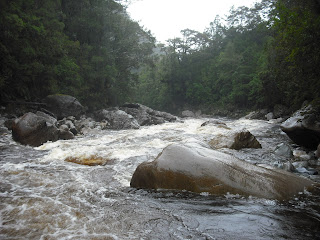
As a kayaker one of the joys of living in Westport is the close proximity of the Waimangaroa River – our backyard run.  A 15km drive north to Waimangaroa and a 15-20 minute walk gets you to the put in of one of the better after work runs in the country.  While no more than class III/IV, it definitely has still got enough going on to keep you concentrating, and provides the necessary whitewater fix which keeps you coming back again and again.  Of course the only thing you need is a bit of heavy rain – which doesn't come often enough for my likening – and you are doing well if you manage to get out on the run a dozen times a year.

From the Waimangaroa settlement a gravel road heads up the south bank of the river for a little over a kilometre before reaching the bottom of the Denniston Incline.  After leaving the carpark on foot the track soon crosses Conns Creek and is then rejoined a little way above river level.  If the Conns Creek crossing is up to your waist, and you are starting to have second thoughts about whether or not this is such a good idea, then the Waimangaroa is starting to get really high.

The track follows an old railway line which is long abandoned but nonetheless provides good access up the river.  After 500m the track ends at the Crossing where it is necessary to cross the river to continue further upstream.  From the Crossing to Conns Creek it is class III, and above the Crossing it is class IV.

One of the better parts of the track on the way to the Crossing

The Crossing rapid
On the opposite side of the river the track is rejoined after climbing up a small rockfall.  Upstream of the Crossing the track is harder going, but it's only about 200-300m to the put in (shortly after the tunnel).  At the put in there is a nice spot to do some ferry glides, and the first rapid also provides a bit of a warm up before the business starts.

Hard right is the standard line on the first drop.  The big rock on river left is undercut, but I have only ever seen someone go under there once, and it flushed pretty quick.

 
The first drop
  From here it is pretty busy through the next few rapids to the bottom of the Crossing rapid.

Below the first drop
 
At the top of the Crossing rapid after a bit more rain
Below the Crossing the river eases up to class III until Conns Creek, from where the river steepens and there are a couple of class IV rapids to negotiate.
 
Rapid below the Conns Creek confluence
The infamous Undercut is the final rapid of note, and while not overly difficult, the potential consequences of getting yourself somewhere where you shouldn't be makes it one of the more serious rapids on the river.  The big rock on the left forms a large underwater cavern through which a significant amount of flow passes.  It is not be underestimated and has been the scene of some potentially very nasty incidents over the years.

The infamous Undercut rapid
Below the Undercut rapid there are some nice class III rapids before the river flattens off to class II.  If the river is high enough and you are interested, the rock groyne a further 1.5km downstream (at the railway and road bridges) can provide some entertainment.

Friday, 14 June 2013

Glasgow Range

You can't beat a fine winters day on the Coast.  So with only mid-week sunshine of late, it was time to skip work for a day, get up high with a view, and try and banish those blues.

Heading up to the Glasgow Range inland from Seddonville is a great little day trip which provides the quickest and easiest means of getting up to around 1500m on the West Coast.  The track heads up to the prominent open tussock land which can be seen directly ahead while driving up the main road through Seddonville.  With the bush line being relatively low here, it doesn't take long to get up high enough to start getting some views.    

Access to the start of the Glasgow Range Track is via Marris & Woollet Roads which branch off from Charming Creek Road about 100m before the Chasm Creek Bridge No.2.  From the turnoff it is about 3km up these old forestry roads to the start of the track.  While drive-able in a 2WD, the roads are deteriorating, and there are a few steeper rougher sections which have the potential to do some damage.  So taking a 4WD or mountain bike might be a good idea.

The start of the track is sign posted and initially heads up and old 4WD track.  After the track starts proper it soon crosses Tate Creek, and from here a good DoC marked track heads up a broad and not too steep ridge.  The first bush line can be reached from Tate Creek after about an hour.  The track crosses scrubby open tussock land before soon re-entering the bush on the right.  From here the track is a little more difficult to follow and is marked with a combination of DoC markers and pink cruise tape. 


At the first bush line
From the second bush line the route is poled, and after an initial gentle slope a step section, which requires a bit of scrambling, must be scaled to gain access to the upper ridge.

The upper ridge and final approach to the top (Pt 1469)
Three hours by mountain bike and foot at a decent pace from Charming Creek Road usually gets me close to the top.  Pick a fine day and you will be rewarded with fantastic views in all directions.

View towards Reefton and the Paparoa

Tarns in the head of Mountain Creek.  Look closely at the mountain (Rocky Tor) in the background and you can see the Old Ghost Road.

View directly towards the Haystack and Mt Owen
Apart from a cool southerly breeze the day was perfect.  After sitting in the sun for an hour on the sheltered northern slopes, it was time to take some more photos and slowly head back downhill.

The Ngakawau basin and Stockton mine
Making my through the warmth of the sunny lower bush in a T-shirt was magnifique.

Monday, 3 June 2013

Styx & Inangahua Rivers

A warm northerly air flow was forecast to bring rain to the coast over the long weekend.  Frustratingly the really heavy rain didn't arrive until Monday afternoon/night.  After spending Saturday biding my time I came up with a plan to head down to Hoki early the next morning if it didn't rain in Westport overnight.

Arriving mid morning at the Styx, it was looking like it had plenty of water and was definitely good to go.  After a couple of warm up runs down from the lower corner I was in luck as a team of local paddlers showed up.  Following in behind and paddling some of the rapids higher up the river, at 10 times the flow it had been when I was last here in February, was a real hoot.

Back in Hoki I lined up a couple of Canadian's for kayaking the following day, but that plan fell through in the morning.  So on my way home I was on the lookout for a creek which was new to me and had a bit of water in it.  Blackball Creek had some water and was a possibility, but I continued on as I was keen for my first run on the Inangahua River.

The level looked a bit low in the open lower reaches of the Inangahau, but it was raining steadily and there was more than enough water for the more confined upper section by then time I got to Tobins Bridge.  The upper section starts about 2km upstream of Tobins close to where the road makes some bends marked 55km/h.  Two hundred metres downstream of here the river is in open view of the road where a side stream makes and entrance – this spot is immediately above the first waterfall. 

There are three big drops from the upper put in and you can choose which ones you put in for.  The top drop is a tight and nasty 5m waterfall with an exit width of less than a metre.  It's possible to get in below this above the a classic 7m metre waterfall that's walled in.  The final drop is a steep and continuous class IV rapid which requires some moves to negotiate the obstacles. 

I put in below the second waterfall and paddled upstream into the bedrock gorge.  The waterfall was thundering and I was treated to the sight shown below (photos are courtesy of Zak Shaw www.passion4adventure.blogspot.com who was also recently on the Inangahua).

Paddler on the second of the waterfalls

Below the third drop the rapid the river flattens off for a bit before steepening up again and entering a rapid where the river makes an S-bend in a short gorge.  There is a steep long entrance so eddying out to take a look or portage will require some forethought especially at higher flows.  A hole at the entrance to the gorge tends to wash out at higher flows, and another smaller drop around the corner shouldn't cause major problems before the pool at the bottom.  S-bend rapid is right beside the road and is easily accessed from the culvert 100m upstream of the Patterson Creek road bridge.

Paddler negotiating the hole at the entrance to S -bend gorge

From here the river remains continuous class III/III+ until the final class IV rapid immediately upstream of Tobins Bridge.  This is a good spot to check out the flow, and if you don't like the look of the rapid immediately above the bridge, you had best not venture further upstream because it gets more difficult. 

After the first rapid below Tobins Bridge the river changes character and becomes much more open, wide, and flat.  Rapids are mainly shallow class II+ boulder gardens which are punctuated by 20 or so class III rapids where the river steepens or is constricted over the next 8km.  Take out can be arranged at various spots where the river and road meet. 

Arriving back at the car above Tobins the river had risen considerably and everything in the Upper was looking a whole lot bigger waterfalls included.

The upper Inangahua section is beautiful and a really good spot for those looking to improve their class IV technical creeking skills.  There is nothing else that compares in the Murchison area and I can't believe it hasn't received more action given its roadside location.  I can't wait to go back!  It should only require medium rainfall to be runnable, and for those interested at high flows it will be continuous, committing, and an awesome ride.  While no Little While Salmon it would be an great spot for a class IV extreme race if it had a dependable flow.

The following pictures show the main drops at low flow (mid November 2013).

Top drop (very tight and nasty) from the lip of the second drop

Second drop is about 8m

Third drop

A tree is currently stuck in the middle of S-bend rapid